Germany 1789 -
Interactive • English Version
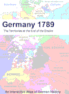
40 maps show Germany and its
territories within the Holy
Roman Empire of German Nation at the end of the 18th
century. Additionally there are direct links to the Wikipedia articles.
Ideal for teaching, genealogy and
all people interested
in history.
The graphical quality of the pdf-version
is significantly higher than on the website pages.
All 40 maps and a legend as pdf-file -
zooming up to 400%
printable up to A3-format
|

Deutsche Versionen bitte hier klicken |
-
Direct Download
Price 29 €
-
CD-ROM shipping included
Price 39 €
Shipment within 2 days
-
Payment by credit card, bank transfer or cheque.
-
Demo version appr. 1,2 MB
more
-
Information:
info@hoeckmann.de
|
 |
|
More excellent historical maps at
euratlas |
 |
Euratlas Periodis
Expert
Historical Atlas of Europe
English Version
-
Direct Download
Price 55 €
- CD-ROM shipping included
12 €
Shipment within 2 days
- Europe from
the year 1 to 2000
- one map for
the end of each century
-
more
details
- also
available with a teachers license or site license
|

|
Euratlas Periodis
Expert
Geschichtsatlas von Europa
Deutsche Version |
Deutsche Version jetzt auch verfügbar - bitte hier klicken |
The Meyer Handy
Atlas 1892
by Verlag des Bibliographischen Instituts, Leipzig und Wien
in German with map titles in German, English and French
|

|
The Asian Turkey
map (Asiatische Türkei) 1872
by Johann Samuel Heinrich Kiepert
in German only
|

|
|
Historical and Political Maps of the Modern Age version 0.8
-
Direct Download
Price 22€
-
CD-ROM shipping included
32 €
Shipment within 2 days
-
A selection of world political and
historical maps from 1789, and occasionally from earlier dates, to
the present day organized by region and dates. Most of the maps are
in Spanish
-
more
details
|

|
-
Post-roads in Europe
1781
-
European Turkey and
Greece
-
Historical Vector Maps of Europe
-
Physical Vector Map of Europe
-
Ancient Rome Vector Map - Roma Antiqua
|
For more historical maps see
|